

From the top of Tri-Peaks overlooking the Conejo Valley (Elevation 3,010 Feet)
DAY 192: Boney Mountain to Tri-Peaks (Secret Trail from Newbury Park)
Date: Wednesday May 25, 2011
Miles: 9.5
Elevation Gain: 2800 Feet
Time: 3.5 Hours on a fast pace/jog (Reserve a half day and enjoy yourself!)
Difficulty: Pretty simple until you reach the Monument where the real climbing begins. The final stretch will put you down on all fours to scramble up the loose rock and dirt. Only the fittest and agile hiker should attempt this climb. That said, why am i doing it :)?
Reward: King of the World; the Highest Point in the Santa Monica Mountain Range!
Description: Follow the marked trail to Danielson Monument. Then, take the off-map secret trail to the top. The trail is easy to find but you will climb +2000 feet over the last 2 miles...
Where: Newbury Park, CA
Directions:From the 101 Freeway in Thousand Oaks, exit on Wendy and head south. Take Wendy to Lynn a and turn right. Drive past the next major intersection, Reino Rd. and then look for the National Park entrance on your left. There will be a brown sign identifying the turn off. Drive to the back and park.

I finally bought a map of this wilderness. Of course, the "Secret Trail" that I was about to hike was not marked on the map! The trails that I have hiked are highlighted but the specific route I was taking today is highlighted in pink/orange and begins near the Satwiwa Culture Center. The highlighted section after the Monument is not exact...

Park your bike, or car, and let's go! (Elevation 800 feet)

The first quarter mile: Boney 5 miles ahead!

Cross the road and the bridge

Turn right after the 1st bridge (the 2nd bridge takes you to the center)

The 0.4 mile trail across the field leads to the mountain entrance
I explored this area on DAY 178. I will be retracing footsteps for about 1.5 miles from the Satwiwa Loop Trail to the Monument cut off. Click the (Pic's) for more details...
Pic: Head Up the Hill then Pic: Pass the Bench I didn't rest today; I just kept trucking! Pic: Go to the Right (Follow the signs to the Monument). (Elevation 1060 Feet, an easy +260 from the trailhead) You will then drop nearly 200 feet and reach: Pic: Water Crossing. If you continue to follow this trail, you will reach the waterfall. Instead, when you see an obvious switchback to the right, take it up higher. After a series switchbacks you will intersect a junction:

The sign reads (Site Cabin)
Stay straight on this trail. Do not take the switchback trail that heads up and to the right. This would lead you to the Fossil Trail. There is a well marked sign (you're only 0.3 miles to the Monument).

It must be butterfly season...

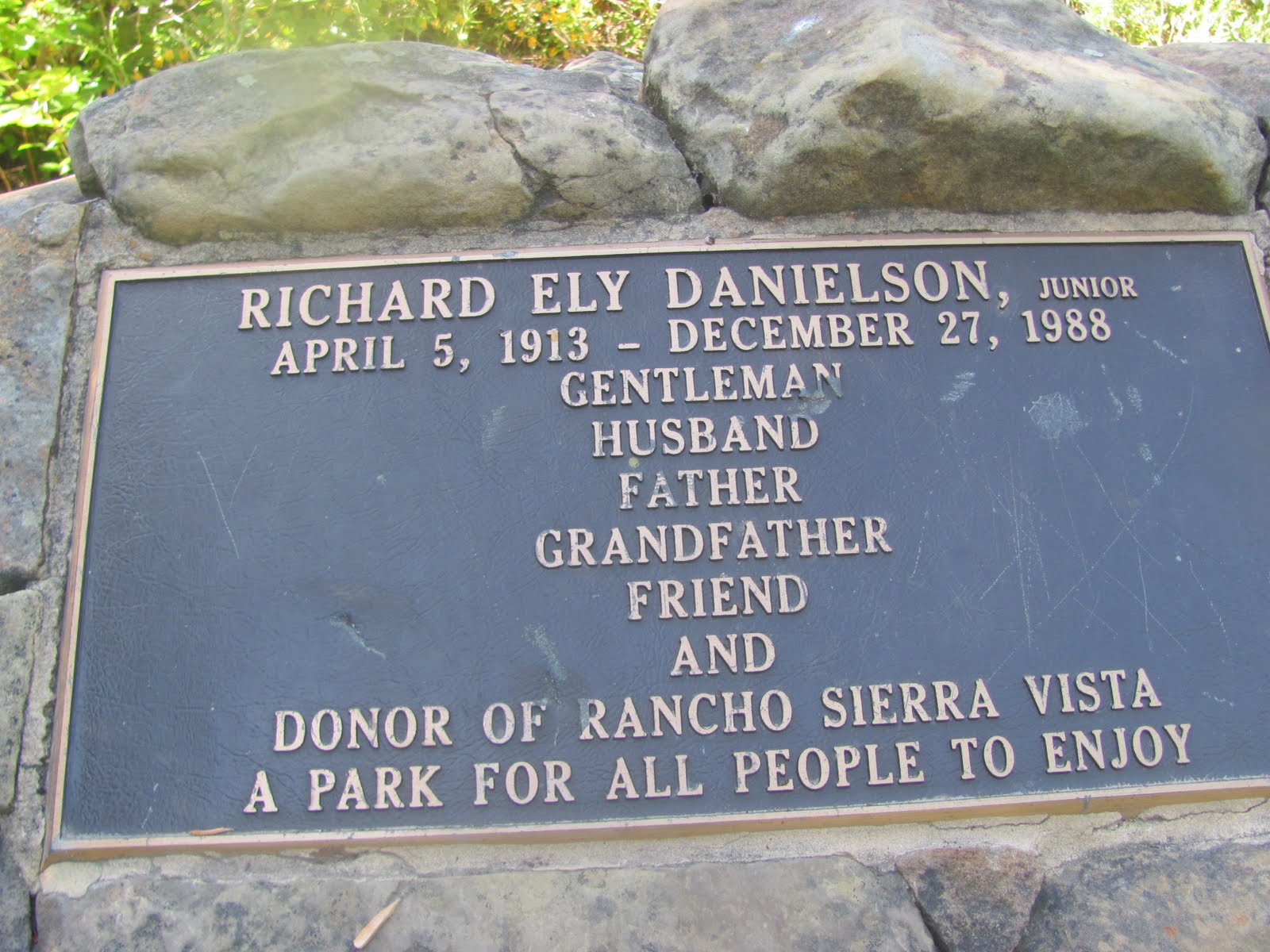
Danielson Monument (Elevation 1460 Feet)
1 hour of hiking: 2.6 miles +860/-200 feet

You'll see this trail just before the Monument. Take a rest if you'd like and then head in. This is where the map ends. I felt apprehensive. To make matters worse, I heard loud footsteps in the woods. I picked up a rock and crept forward. I did not know what to expect...

A fireplace; I'll come back next week and build a house...

The incline begins!

Nicely shaded and the trail is easy to follow

Into the open; fortunately it was not hot!

Challenging (be sure to pack plenty of water)

Good spot to take a breath and admire the view

Instead, I stand on the rock, take a pic and keep going!

Scramble across a rock and then head lower and into it

Prepare for the final accent

Getting kinda sketchy up here; be careful!

It's worth it!

You see where you have to go, so go there!

Seal Treasure Ahead
You just came up some of the toughest climbing. The steep shaded trail is made up of loose dirt and rock. I had to use all fours to reach the boulder that you see in the picture above. I am being a bit dramatic; it wasn't that bad. Maybe it was the fact that I just climbed over 2000 feet and refused to rest. I figure that I'm an old man and like George Foreman fought in his later years, he didn't sit down between rounds and neither will I... **If you are following the Seal Treasure Game from SEALtheBeach.com, your treasure awaits you. It's impossible to miss this boulder. At the edge, take one step up and look to the right:

The Seal Treasure
I hid the bottle just behind the reachable edge of the wall and covered it with some rocks. As always, bring a pen or take a picture of the clue and then place it back in the bottle for the next hunter... Before you head back home, climb up the final 100 feet to the top of Tri-Peaks:

Up and along the wall...

Take a look around...

Across the Boney Valley, Ocean Views!

On top of Tri-Peaks!


Mission Complete! Retrace your footsteps from the highest elevation in the Santa Monica Range. You can slightly see the distant Topa Topa Peak in the Los Padres National Forest. Typically, the clearest days are in the winter months. These are also the best times to hike, except for when it rains. There are more peaks to climb and caves to explore on the other side of this Boney Valley but the hour was growing old and I had to race the sun back to my bike. I will return! There are shorter trails that leave from Yerba Buena Road, on the Malibu side of the mountain.

Don't forget where you came from...

Heading back down along the wall
The hardest part of the trip was the first quarter mile down off the top. You will slide but you'll make it! Two hours up; 1.5 hours down. My legs were like jelly. I nearly ran right into a deer crossing the trail on the way back. I think we were both at full speed when it happened. **I had a great time and NO POISON OAK!
Yesterday:
DAY 191: Tuesday May 24, 2011
Ranch Overlook Trail: 2.0 miles +50 Feet Elevation
I parked at the same spot as I did on Day 192. I came here today knowing what I was going to do tomorrow so i just wanted to get my legs in motion. From the parking area, I visited the Satwiwa Culture Center and then headed back down the open field trail known as Ranch Overlook. I hiked that about a mile on mostly level suface and then rounded back to the car. Not much to see here except the occasional lizzard and possible snake. I was saving my legs for Wednesday.
**MY 192 DAY SUMMARY: 643.5 Miles +84,850 Feet**
Goals
To the best of my knowlede, in the half year that I have been hiking I have surpassesed all possible elevations of the universe. For example, the peak of Olympus Mons on Mars is 69,649 feet above the Mars areoid (the assumed sea level on Mars if it had water). The Olympus Mons is a massive volcano that stretches 300 miles wide. Based on the surrouding landscape, which would below sea level, Olympus Mon raises about 82,000 feet from the lowest level.
Part of my hiking aspiration is to achieve good health and set new goals. I now have my mind set on reaching the elevation of the International Space Station. At it's lower levels above the Earth's atmosphere, the Space Station sits 200 miles above our planet. That means I will need to climb about a million feet total! Thus far, I am nearly 20% complete toward my 1000 day total but less than 10% of the height of the Space Station. I would also like to equal my distance traveled to the circumference of the Earth which is 24,859.82 miles. I have only hiked about 2.5% of this so far. Bottom line; I will need to hike further, higher and faster to acheive these goals. That means, I will have more amazing hikes in the up coming months. Stay tuned...


Hey Jeremy, I was on the Boney Mtn. hike on Sunday, and found your clue behind the large rock wall you mentioned here. I had never previously heard of this website or your 1000 hike challenge, and I was excited to have stumbled upon a "secret clue." Thanks and good luck on your challenge!
ReplyDelete-Ryan Newkirk
CSU Channel Islands
yeezy boost 350
ReplyDeletegolden goose sneakers
off white clothing
air jordan
jordan 4
bape hoodie
bape clothing
curry 6 shoes
curry 7
nike air max